
A plateau country of red basalt soil, forest and river valleys, between 500 and 1,500 metres above the sea, some 54,548 square kilometres of it. Its boundaries were drawn on 27 May 1946 by the colonial power itself — and the drawing left out the coast we had already been driven from.
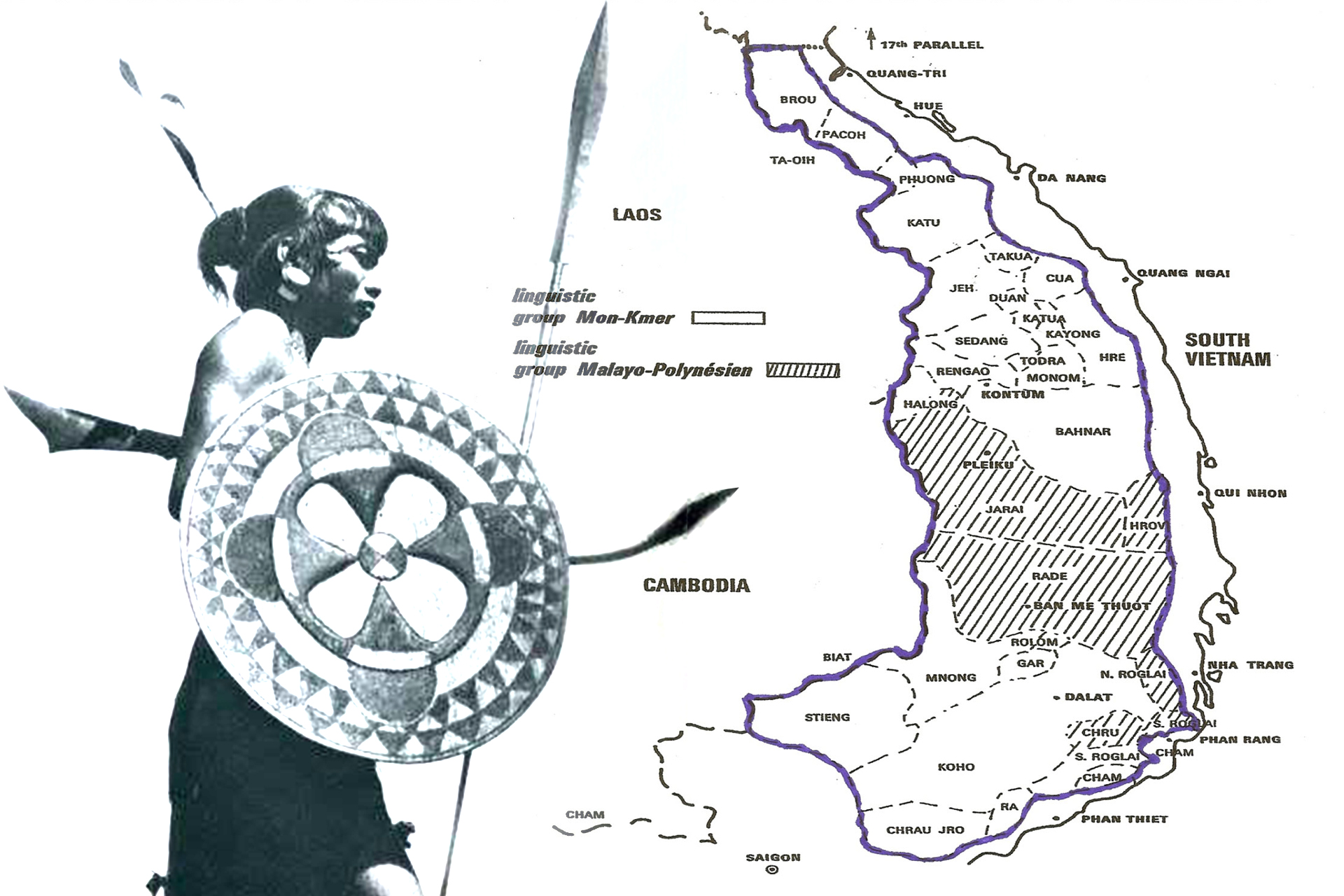
The land
The Central Highlands are not one plateau but a series of them, stepping down from the Annamite range in the east toward the Mekong lowlands in the west. From north to south: the Kon Tum plateau; the Pleiku plateau; the great basalt tableland of Dak Lak around Buon Ma Thuot; the Mnong plateau of Dak Nong; and, highest of all at around 1,500 metres, the Lam Vien plateau around Da Lat, which the French turned into a hill station for exactly that reason.
Four river systems drain it, and they drain it in two directions — a fact with consequences. The Se San and the Srepok run west into the Mekong, carrying the northern and central highlands into Cambodia. The Ba (Da Rang) runs east to the sea at Tuy Hoa. The Dong Nai runs south toward Bien Hoa and Saigon. A country whose water goes both ways is a country that has always had roads in both directions, which is why the highlands were a trading crossroads long before they were a frontier.
The soil is the other fact. Weathered basalt over much of Dak Lak and Gia Lai produces some of the most fertile agricultural land in Southeast Asia. More than 290,000 hectares of it are now under coffee, about 80 per cent of Vietnam's national production, with around 170,000 hectares in Dak Lak alone. Rubber, pepper, cashew, mulberry and silk follow behind. That soil is the reason the highlands were wanted, and the reason the wanting has never stopped.
The boundaries of 1946
On 27 May 1946 the French High Commissioner, Admiral Georges Thierry d'Argenlieu, created by decree the Pays Montagnard du Sud-Indochinois — the Montagnard Country of Southern Indochina — as an autonomous territory within French Indochina, administered by a French delegate with direct authority.
Inside that line sat the provinces the world now knows as Kon Tum, Gia Lai, Dak Lak, Dak Nong and Lam Dong, together with the upland districts of the provinces around them.
What the boundary left out
Dega accounts hold that our people once occupied most of southern Indochina — from the 17th parallel to the tip of Ca Mau, and from the east coast inland to the mountains. The Cham reached the northern coast around Danang in the ninth century; the Vietnamese destroyed the Cham capital at Vijaya in 1471 and, by the late seventeenth century, had pushed Cham survivors south toward Bien Hoa and into Cambodia. Each wave pushed us further from the sea.
When the French drew the line in 1946 they drew it around where we had ended up, not around what had been taken. The coastal strip was left outside. We record this not as a claim being pressed today, but because a boundary is a document, and it is worth knowing what a document leaves out and who benefits from the omission.
What happened to the line
The autonomy lasted four years on paper and rather less in practice.
- 15 April 1950 — Bao Dai, Chief of State of the State of Vietnam, issues Dụ số 6, Decree No. 6, incorporating the PMSI into the Domain of the Crown. The highlands become the Crown Domain of the Southern Highlander Country, held by Bao Dai personally rather than by the Vietnamese state. The distinction mattered then and matters to the legal argument now.
- 21 May 1951 — Bao Dai issues a special statute guaranteeing the highland peoples free evolution in accordance with their own traditions and customs. We were not consulted before the handover, and under French authority we were in no position to refuse either the transfer or the guarantee.
- 1955 — Ngo Dinh Diem, having displaced Bao Dai, merges the highlands into the Republic of Vietnam. The special statute is set aside, the customary courts are wound up, and the land development programme begins the following year. No government objects.
Why a colonial decree is in a Dega library
Because it is evidence, not because it is authority. The 1946 decree and the 1951 statute do not create our right to the highlands — that right rests on having been there first and continuously. What the documents do is establish that two successive sovereigns, the French Republic and the Vietnamese Crown, both recognised the highlands as a distinct territory with a distinct people entitled to its own institutions. A state that now denies any such distinction is denying something its own predecessors wrote down.
Terms
- PMSI Pays Montagnard du Sud-Indochinois
- The autonomous Montagnard territory created by decree on 27 May 1946.
- Crown Domain Hoàng triều Cương thổ
- The status conferred on 15 April 1950, placing the highlands under Bao Dai personally rather than under the Vietnamese state.
- Annamite chain Chaîne Annamitique, Trường Sơn
- The mountain range running down the spine of Indochina; our eastern boundary in 1946.
- Buon, Plei, Bon buôn, plây, plếi, bổn
- "Village" in Rhade, Jarai and Mnong respectively — the unit that the plateau is actually made of, and the word that begins most place names in the highlands.
Sources
- Pays Montagnard du Sud-Indochinois — the 1946 decree, provinces, capitals and Dụ số 6
- Central Highlands (Vietnam) — area, plateaus, coffee hectarage and 2022 population
- Gerald C. Hickey, Sons of the Mountains (Yale, 1982) — the 1946–1955 sequence in detail
- Montagnard Foundation, Inc., historical summaries (archive held by DCHO) — the 1951 statute and the pre-colonial territorial account
Compiled September 2026. We are looking for a scan of the 21 May 1951 statute in the original. If you have one, or know which archive holds it, write to us.